Bruce Highway (Brisbane - Gympie), Gateway Motorway to Dohles Rocks Road upgrade funding commitment

The Bruce Highway (Gateway Motorway to Dohles Rocks Road) project is part of integrated planning for the Gateway Motorway and Bruce Highway Upgrades in north Brisbane and the Moreton Bay Region.

Benefits

  • Improves safety
  • Increases capacity
  • Improves network efficiency
  • Increases traffic flow
  • Better road access
  • Contributes to economy
  • Contributes to regional growth
  • Better active transport

Key features

The Bruce Highway (Gateway Motorway to Dohles Rocks Road) business case developed a plan to improve traffic flow and safety by:

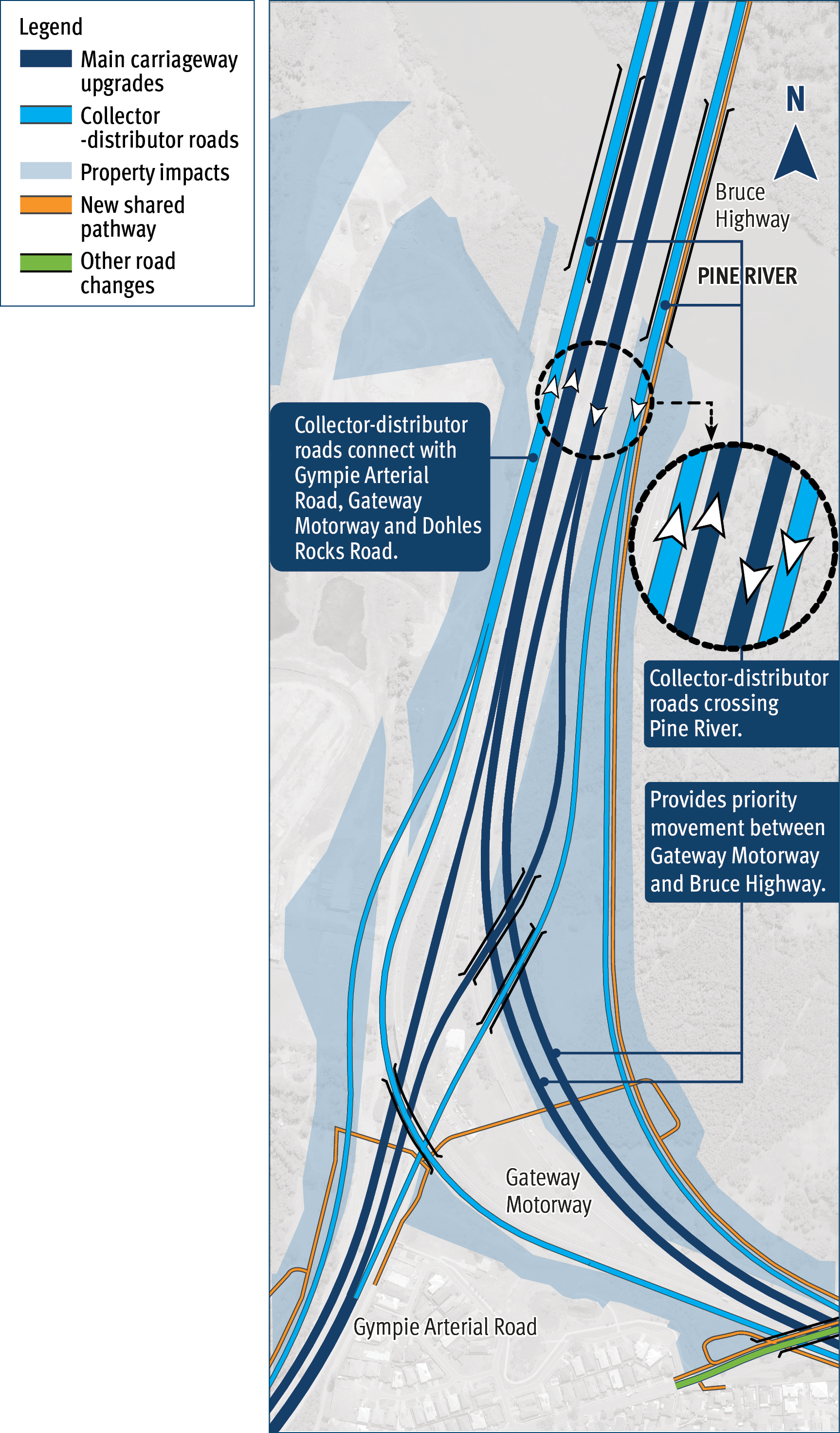
  • providing collector-distributor roads on both sides of the Bruce Highway between Gateway Motorway and Dohles Rocks Road
  • constructing new bridges over the Pine River to accommodate collector-distributor roads
  • reconfiguring the Bruce Highway, Gateway Motorway and Gympie Arterial Road interchange
  • installing a shared pedestrian and bicycle path adjacent to the highway, including across the Pine River.

Future planning consideration:

Planning for this project also consider upgrading Gympie Arterial Road between Strathpine Road and Gateway Motorway, to address traffic flow and connection with Bruce Highway. This is recommended as a future stage, to be delivered subject to funding and competing priorities.

Funding

This project is jointly funded by the Australian and Queensland governments. Project scope, cost and timing are subject to further planning, consideration, and negotiation with the Australian Government. Investment ID 1509103

A revised project cost of $1,930 million was announced on 22 December 2023.  

Funding figures as at QTRIP 2023–24 to 2026–27 (June 2023).


Total investment
$948 million
Australian Government
$758.4 million
Queensland Government
$189.6 million

Flythrough video

Video Transcript

00:00

Video starts - zoomed out map of north Brisbane area.

Green line depicts project extents - from south: starting at Gateway Motorway at Bracken Ridge, extending north to merge with the Bruce Highway, continuing north on the Bruce Highway through Dohles Rocks Road interchange and north until just south of Anzac Avenue.

  • Labels point to key areas of interest along the green line:
  • Project section: Gateway Motorway (Bracken Ridge to Pine River)
  • Key area: Gateway Motorway – Bracken Ridge curve
  • Project section: Bruce Highway (Gateway Motorway to Dohles Rocks Road)
  • Key area: Major upgrade at the Gateway Motorway/Bruce Highway/Gympie Arterial Road interchange
  • Key area: Dohles Rocks Road exit and entry ramps upgraded
  • Directional labels:
    • To Brisbane (down)
    • To Sunshine Coast (up)

00:34

Labels: Benefits (icons):

  • Increase capacity and reduce congestion
  • Improve safety
  • Improve freight efficiency
  • Better active transport

00:43  

Label: Upgrading one of Queensland’s busiest road corridors

Label: Traffic levels to increase by more than 50 per cent in 20 years on the Gateway Motorway and Bruce Highway

01:00

Zooms to start the ‘flythrough’ at the southern extent of the project

Gateway Motorway at Depot Road - facing northbound.

Moving northbound along Gateway Motorway starting at Depot Road Bracken Ridge, near the Deagon Deviation.

Labels: Gateway Motorway and Deagon Deviation

Label: Additional lanes in both directions (on the Gateway Motorway)

Label: 100km/hr speed limit

01:14

Gateway Motorway is lowered as it curves to the left, under the new Bracken Ridge Road overpass and reconfigured interchange.

Around the curve, the widened Gateway Motorway continues west towards the merge with Bruce Highway.

Label: Gateway Motorway is lowered

Label: Bracken Ridge Road over the motorway

Label: Bracken Ridge Road Exit ramp

Label: Bracken Ridge Road

Label: Upgraded Bracken Ridge Road Exit and Entry ramps

01:46

Upgraded Bracken Ridge Road entry and exit ramps shown joining Gateway Motorway, on left.

Tinchi Tamba Wetlands (on right of motorway)

Label: Fauna fencing along Tinchi Tamba Wetlands (on right of motorway corridor)

Label: New bridges over Bald Hills Creek.

Label: Potential fauna underpass (shown near Bald Hills Creek corridor)

02:02

Label: Wyampa Road

Upgraded Wyampa Road overpass bridge travels over the top of the Gateway Motorway lanes.

Northbound collector-distributor road exit lanes shown on the left of the motorway.

Southbound collector-distributor road lanes enter/merge with motorway on the right.

02:13

Top left of screen: orange line depicts future upgrades to the Gympie Arterial Road

Label: Future upgrades Gympie Arterial Road

02:14

Label: major interchange upgrade

02:17

Flythrough comes into the Gateway Motorway/Bruce Highway/Gympie Arterial interchange

Label: Gateway Motorway priority connection at 100km/hr.

Gateway Motorway merges with the Bruce Highway at ground level.

Northbound collector-distributor road traffic travels on flyover over the Gympie Arterial Road, arcs to the left and then joins/merges to run adjacent to the Bruce Highway, northbound.

Label: Potential fauna overpass

Label: To Gympie Arterial Road

Label: Bruce Highway

02:30

Southbound collector-distributor roads are depicted on the right of screen, with exiting traffic joining the Gateway Motorway, curving to the right.

Southbound collector-distributor traffic exiting to Gympie Arterial Road travels on a flyover over the Bruce Highway corridor to merge with the Gympie Arterial Road.

Label: Southbound collector-distributor

02:37

Flythrough travels north along the widened Bruce Highway, extending over the Pine River.

Northbound and southbound collector-distributor roads are shown on either side of the Bruce Highway (northbound on left, southbound on right of highway corridor).

Additional bridges are shown over Pine River on either side of Bruce Highway to accommodate the CD roads.

Label: Northbound collector-distributor

02:40

A green highlighted line is shown on the right-hand side of the new southbound collector-distributor road, depicting the new shared pathway for pedestrians and bike riders extending north, adjacent to the Bruce Highway road corridor.

Label: Shared path over the Pine River (right hand side-East)

02:41-6           

Label: Potential fauna underpass, on northern side of the Pine River. To assist east-west fauna movements under the Bruce Highway corridor.

02:58

Flythrough continues north, depicting widened Bruce Highway and additional northbound/southbound collector-distributor roads on either side of the Bruce Highway corridor.

Label: Bruce Highway to Sunshine Coast

03:13

Northbound collector-distributor road exits to the left of screen to Dohles Rocks Road.

Label: Collector-distributor exits to Dohles Rocks Road

03:13

Southbound collector-distributor road from Dohles Rocks Road enters on the right of the screen.

Label: Dohles Rocks Road entry to collector-distributor.

03:27

Flythrough slows to hover at the Bruce Highway - Dohles Rocks Road interchange.

Dohles Rocks Road runs east-west under the Bruce Highway corridor.

03:28

Flythrough stops moving - looking north:

Label identifies the start of the Bruce Highway (Dohles Rocks Road to Anzac Avenue) Stage 1 project.

On left:

  • Label: New extended entry ramp
  • Orange line: depicts new entry ramp extending north on Bruce Highway from Dohles Rocks Road.

On right:

  • Label: New extended exit ramp
  • Orange line: depicts new exit ramp extending south from Bruce Highway to meet Dohles Rocks Road.

03:35

  • Music stops. Branding slides. Australian Government logo and Queensland Government logos.

Video ends.

Current status

Business case is expected to be finalised in mid-2024.

Have your say

Community consultation for 2023 is now closed.

The department would like to thank the community for providing feedback on the recommended planning for the Bruce Highway (Gateway Motorway to Dohles Rocks Road) section.

A summary of the feedback will be made available soon.

The department will continue to engage the community with further consultation periods when planning progresses to design and construction. For more information, please visit the consultation page.

Recommended plan: Major upgrade at Bruce Highway/Gateway Motorway/Gympie Arterial Road interchange

Sustainability

The department incorporates social, environmental, and economic costs and benefits when assessing and delivering infrastructure projects. These broad elements of sustainability are implemented using the Infrastructure Sustainability Council Rating Tool. The Infrastructure Sustainability Council program incentivises various sustainable initiatives, including best practices pollution control, environmental protection, community engagement and resource use.

This project will pursue the achievement of an Infrastructure Sustainability Council rating of ‘Excellent’ across both design and construction.

Bruce Highway (Brisbane - Gympie), Gateway Motorway to Dohles Rocks Road upgrade funding commitment location map

Design shows upgraded interchange merging Bruce Highway/Gateway Motorway and Gympie Arterial Roads. Key features depicted include: Traffic on Gateway Motorway travels at 100km/h posted speed, with priority merge onto the Bruce Highway at 100km/hour (travelling at ground level).Traffic travelling between the Gateway Motorway and/or Gympie Arterial Road and the Dohles Rocks Road interchange, use the new collector-distributor roads on either side of the Bruce Highway (northbound and southbound). Two new bridges over the Pine River to accommodate the collector-distributor roads. Shared pathway connections crossing east-west under the Bruce Highway at the interchange and also connecting over the Pine River to connect to southern Moreton Bay region.] 

Map shows area of project on Bruce Highway from the Gateway Motorway merge north to Dohles Rocks Road interchange. This map shows the project area extending south from Bruce Highway onto Gympie Arterial Road through to Strathpine Road.